


THE CITY OF LOS ANGELES WPA SKETCHBOOK
An Unexpected Treasure Waiting to Be Found

It’s been a while since my last post, and rather than drone on about the evils of the Department of City Planning and their servitude to developers, I want to switch gears and laud the efforts of the Los Angeles City Clerk in preserving our history.
The Office of City Clerk maintains a treasure trove of records and documents that help shine a light on our past. From the various Board and Commission meeting minutes to the City Council files dating back to the cities’ founding, one never knows what you’ll find once you take that first step down that rabbit hole.
“Mike, I’m impatient, take me to the WPA Sketchbook NOW!”
Okay, here you go. But be warned, the sketchbook consists of 6 volumes and more than 1,200 sketches published in a coffee table format. It’s easy to get lost without a roadmap. After looking at the Sketchbook, I hope you’ll return and read a little bit of the history behind its preparation.
BACKGROUND
My story begins about 8 years ago when I first became acquainted with Don Ray and his Endangered History Project. Don's project looks to promote the preservation of media in all its many forms. Don also runs a Facebook page entitled "The Spy of Shadow Hills." The “spy” is August Furst, the owner of a famous German restaurant on Sunland Blvd in Shadow Hills.
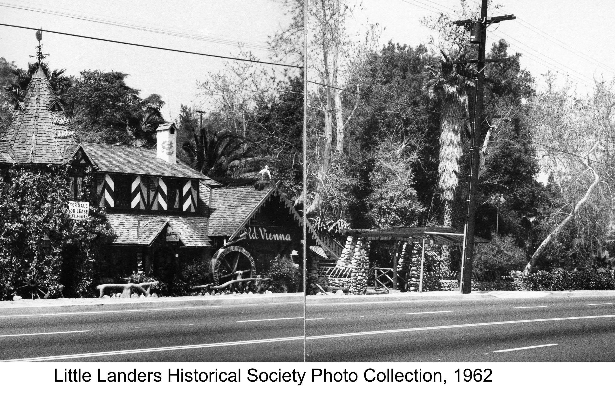
August Furst’s restaurant, the Old Vienna Gardens, was rumored to be a hangout for Nazi spies just prior to the US entry into World War II. There were FBI reports and rumors, crazy rumors, such as armed guards patrolling the hills. Even after the war, rumors continued that Hitler had visited the hilltop retreat. We spent days researching the Leon Lewis files at CSUN to no avail. Leon Lewis ran a local ring of spies who had heavily infiltrated the German American Bund and other local Unamerican organizations. Dig as we might, nothing confirmed the rumors.
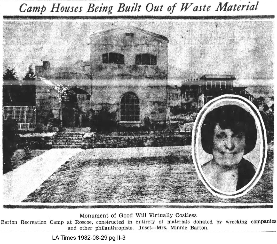
So, if August Furst wasn’t a spy, might the rumors of “armed guards” be due to a case of mistaken identity? Might the reported guards be associated with a neighboring site? One immediate neighbor was Minnie Barton, the first female probation officer in the Los Angeles Police Department. She owned a 13-acre camp adjacent to the restaurant where she housed destitute women. She also founded the Big Sister League who operated a training home for women south of downtown and a home for women with children in Boyle Heights known as the Bide-a-wee Home.
We ventured to the City of Los Angeles Archive over the course of several months to research the Police Commission Board meeting minutes. Reviewing the Board minutes is a slow process because one must review each large bound book page by page. There is no available index or finding aid. Content varies from very scant to highly detailed depending on the preference of the Commission President. If we were lucky, the entry would refer to a City Council file and that file might contain a copy of an official Police Department report. So many entries caught our eye, each a potential item worthy of additional research. Maybe one day I’ll publish an abridged index to the minutes.
We were hoping to find something, anything, that might link the rumors against August Furst to the indigent camp for women run by Minnie Barton. Interestingly, we found that Minnie Barton had to withstand a barrage of complaints from the locals when she first opened her camp. We eventually found the connection, but it would be found a few months later in the Leon Lewis collection. One of his spies had infiltrated the Ku Klux Klan and they had a military unit that trained on the hill right around the same time of the FBI complaints. So, we found our armed guards, and our spy, but neither had anything to do with August Furst.
THE WPA SKETCHES
Helping us sort through this pile of city history was city archivist Mike Holland. Mike is always ready to help researchers find the information they seek. It was during one of our visits that we asked Mike if the city might hold a photo of the Minnie Barton home for married women in Boyle Heights. Mike did not think so, but it might appear among the WPA city sketches. Our immediate reaction was "What WPA city sketches?"
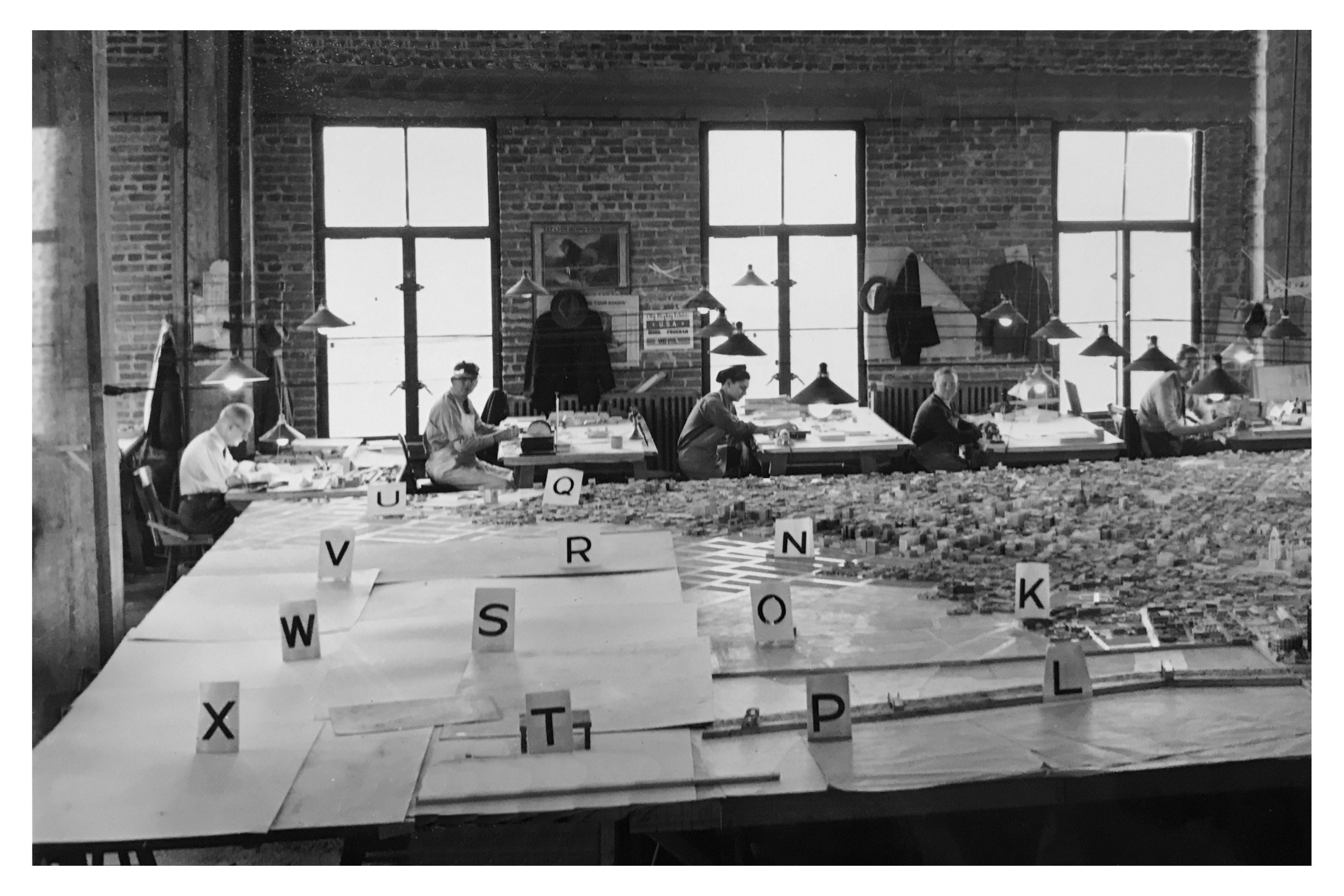
That is when Mike told us the story about the WPA and how they assisted the Los Angeles City Planning Department in constructing a large-scale model of the city. A portion of the model resides in the basement of the Natural History Museum. Prior to building the model, architects went out into the field and sketched the city block by block. Many of the sketches provide an overhead view of each block including side elevation. We were welcomed to look at the sketches, but we were warned that they weren't organized and there was no available inventory.
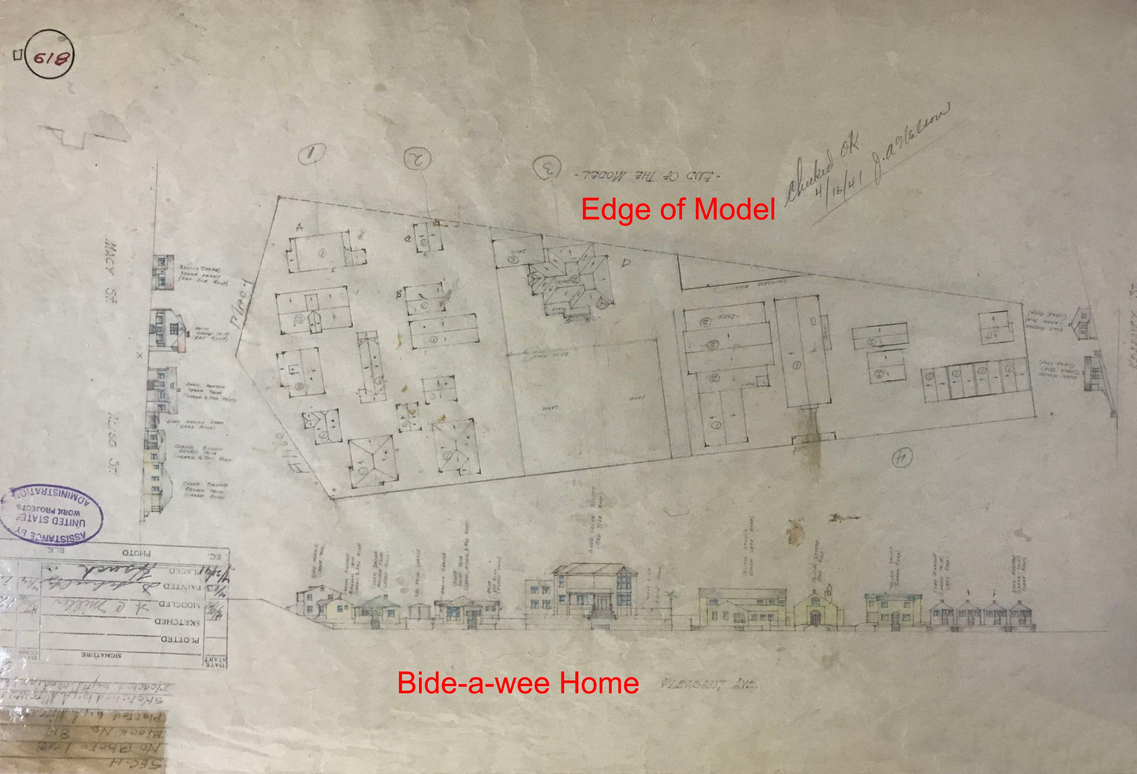
So, out comes several boxes of sketches and we start to dig in. It's tough going since they are not neatly organized and we're not even sure if the home was within the scope of the model. The home sat on Pleasant St, just east of the 5 Freeway. We know that the model on display at the History Museum doesn't go that far east, but might we get lucky?
I gave up after an hour, but Don continued. And then he found it. There was the drawing of the Bide-a-wee Home in its 1940 setting. A line went right across the backside of the building showing the "end of model." If the home sat one more block over to the east, we would have found nothing. But there it was for us to enjoy some 80 years later.
It was right then and there that we decided that the WPA sketches were too great an asset to be buried away in an archive. In addition, we were sure that there were many other discoveries to be made. After all, the physical model on display at the Natural History Museum only represents 20 percent of what was built. And no index to the drawings existed. We were very lucky that we found the Bide-a-wee Home, but short of viewing each sketch one by one, how would others find a given building? A plan slowly came together.
PROCESSING THE SKETCHES
Overall, the WPA sketch collection consists of more than 1,200 sketches, many of which cover portions of the model that are either lost or not on display. Don started the effort by taking digital photos of the collection. Getting a clear shot of each sketch is difficult because many have been laminated (a once common preservation practice). The lamination easily reflects light resulting in glare. Efforts to reduce glare included the use of portable side lights or shooting the sketch on the floor, under a table, to block overhead light.
The next task was to create a searchable archive. Each image file was renamed according to sector letter and block number. There are 24 sectors arranged in a 4 x 6 grid. The organized images were then processed to correct for distortion and skew, cropped to remove any extraneous image, and standardized as to size.
In processing the sketches, care was taken to improve the image while not affecting the basic content of the image. The WPA sketches are a work product, heavily used in the creation of the model and were never intended for publication. As such, most of the sketches exhibit ink stains, soiling, pin holes, adhesive residue, fading, and physical damage such as rips and tears.
With all the sketches processed, it was apparent that some type of finding aid would be required. A master map was created based on planning maps from WPA surveys conducted in the mid to late 1930’s. The red 4 x 6 grid represents the extent of the original model that was constructed by the WPA. The black grid represents the extent of the model currently on display.
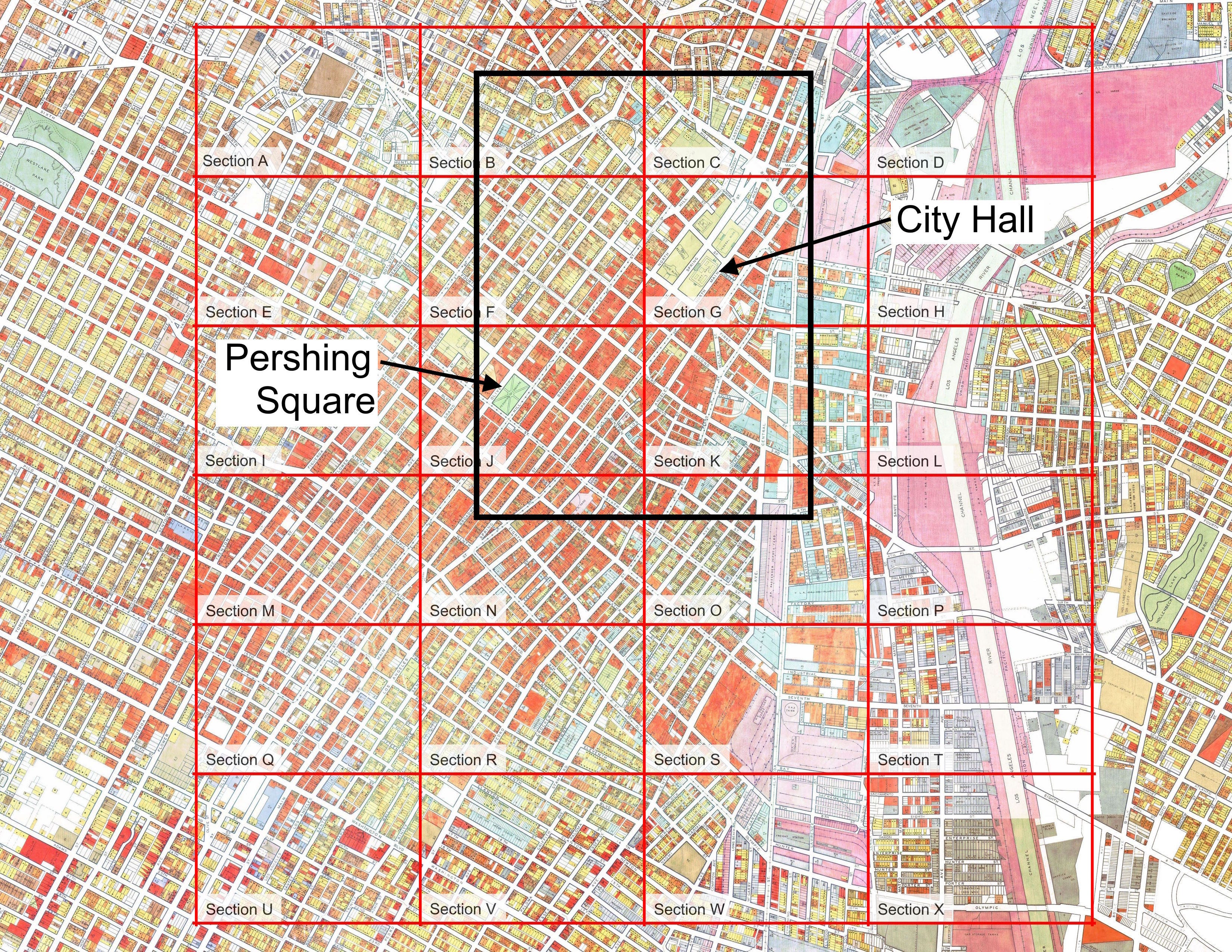
The WPA Sketchbook consists of six volumes, each volume representing one row of the 4 x 6 grid. Each volume contains a high resolution image of each section to aid in the search for a given building. Users should be aware that the actual sector lines are not straight as shown but often zig-zag to follow the block. If the building of interest is located near the edge of a sector, check out the adjacent sectors to be sure that the sketch does not exist.
HISTORY OF THE MODEL
President Roosevelt created the United States Works Progress Administration (WPA), later known as the Work Projects Administration, in May 1935 in response to the Great Depression. During its operation over the next 8 years, about 8.5 million individuals were employed, helping nearly one-fourth of all families in the United States. Much of the employment centered around civic improvement, constructing numerous buildings, roads, airports, water distribution, and sewerage collection facilities. Many people were employed in the fields of medicine, education, music, arts, and writing.
To support the improvement of city infrastructure, the WPA assisted several cities in creating large scale models of their downtown regions. These scale models were an improvement over the use of flat maps since city planners could see how proposed changes impacted the existing buildings and topography.
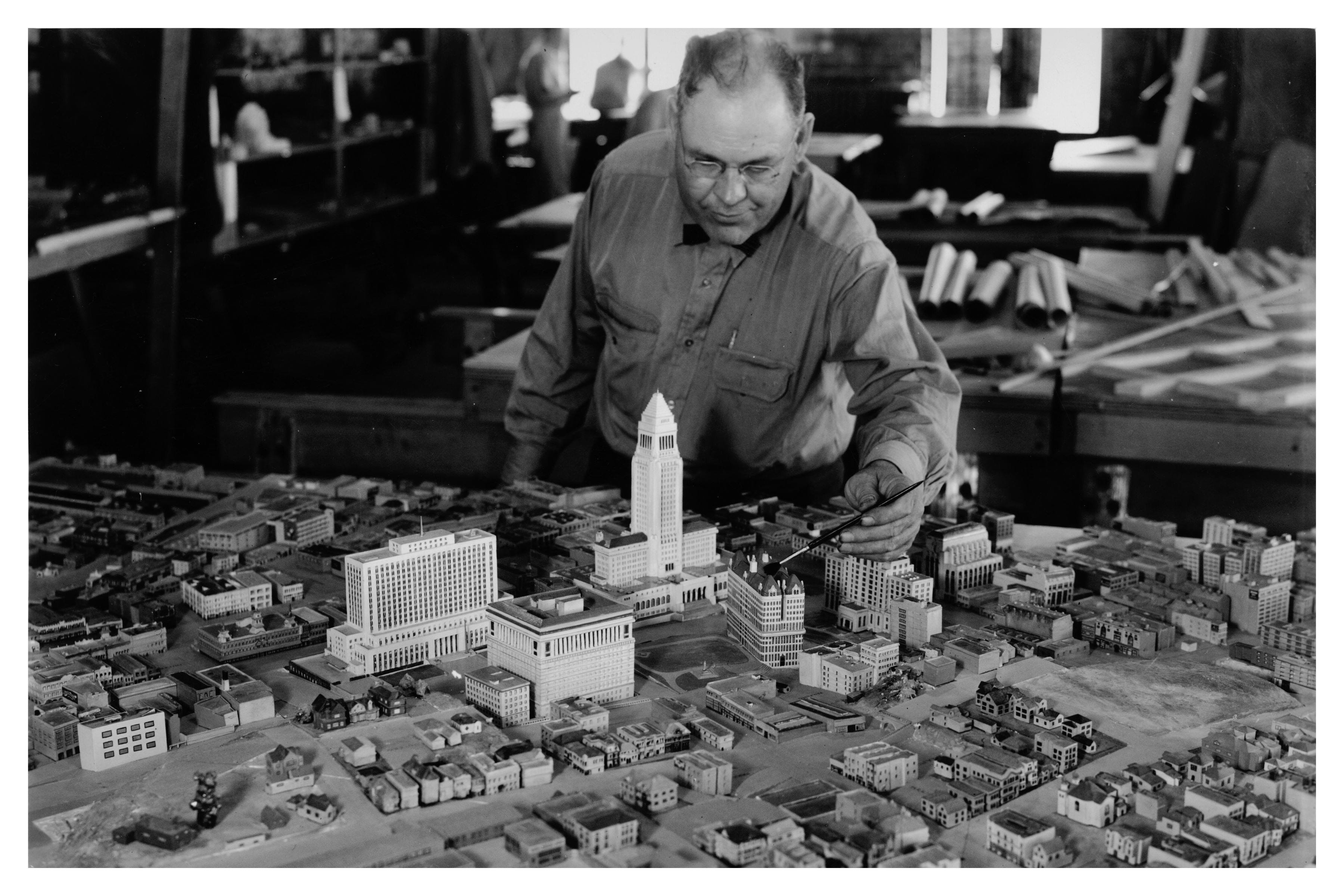
Frank Ostronic, City of Los Angeles Planning Department draftsman and model maker, oversaw the local WPA crew of draftsmen, architects, landscape architects, model makers, and artists. Work began in 1938 with project planning followed by the collection of field sketches and photographs of all existing buildings in downtown Los Angeles. The WPA crew completed the model by mid-1941.
Overall, the constructed model was 24 feet square and built to a scale of 1 inch to 50-feet. The modeled area included downtown, extending from Chinatown on the north, Boyle Ave on the east, Adams Blvd on the south, and Bonnie Brae St near Alvarado Blvd on the west. The model consisted of twenty-four sections labeled A through X, laid out in a 4 x 6 grid.
For many years, the finished model resided on the 26th floor of City Hall. Then, in 1956, the city put out a call for any organization to take the model for free provided they would set it up at a new location for public display. The city considered the model to be obsolete and the department needed space. Some Planning Department staff members worked hard to preserve the model and find it a home. But, with no takers coming forward, the city moved the model to a warehouse for storage.
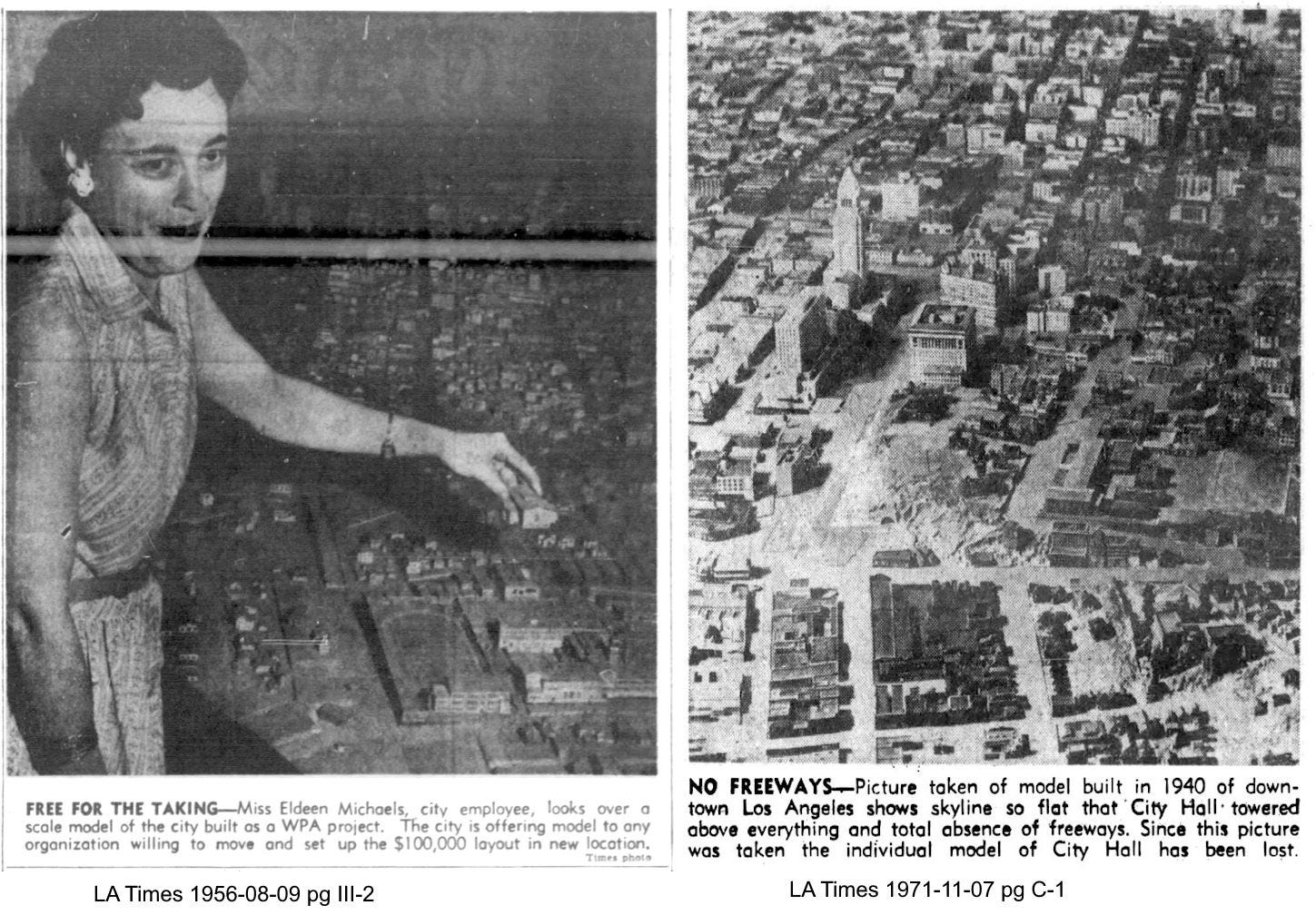
Fifteen years later the model was still sitting in storage. The Los Angeles Times ran an article with photos showing the model of City Hall, but the caption stated that the building was missing. The article noted that the debate over preservation versus disposal continued with no resolution. As a side note, legend is that some retiring City employees received buildings as a memento of their time with the city.
Eventually, the city donated the model to the Los Angeles County Museum of Natural History for use in a major display of California history. The display opened in Lando Hall, in 1980, following six years of preparation. Museum staff restored the model and placed on display an 8 ½- foot x 14 ½-foot section surrounding a rebuilt City Hall.
Today, the model sits on display at the Natural History Museum in Kevin Sharer Hall as part of the permanent exhibit Becoming Los Angeles. The model resides in a state-of-the art glass case that allows a full 360° view while maintaining a climate-controlled environment. The 10-ft x 13-ft horizontal glass case has an integrated sliding platform mechanism that allows access to the model for care and maintenance.
Wow- Mike- what a magnificent undertaking uncovering Lost Angeles! The model reflects a concern by City Planning for the physical reality of the City’s growth. Imagine if any of them cared now?
You and your friends have also revealed the trove of sketches which show our architectural history in situ. Thanks for this marvelous work.
We've struggled to shoot a select sheets of the plastic coated WPA sketches, and know what a remarkable undertaking this was. Thank you! It is a reminder of how essential the volunteer work of caring citizens is to telling the real story of any city, and the value of The Internet Archive (back from a massive hacking attack) as a free, accessible hosting site.
Now we're wondering if there might be a way to crowdsource tagging of specific buildings/intersections on the page they appear on, searchable within the Archive uploads or as a standalone index?